The case for Virtual Low Traffic Neighbourhoods
LTNLow Traffic NeighbourhoodVirtual Low Traffic NeighbourhoodOpen DataMappingGeo Spatial Data
2024-07-15 15:43 +0100
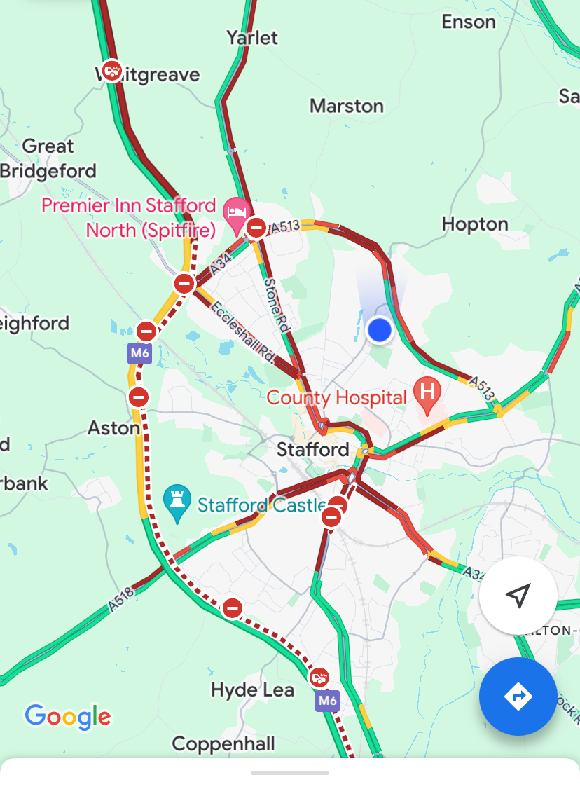
Back in March there was a serious accident on the M6 between Junctions 14 and 13 (Stafford North and South). Accidents happen almost daily on the M6. This one was not fatal and involved one lorry running into the back of another - in human terms, a pretty good outcome in the scheme of things.
Stafford saw an unusually major impact however, as one HGV emptied its diesel tank across the carriageway in the process. This meant the southbound M6 was closed for more than 12 hours - from around 8am until past 8pm. Aside from cleaning up the accident, they also had to hydroblast the carriageway to get the diesel out (or else people would be sliding over the fuel slick and having more accidents).
The outcome was total gridlock across Stafford as three lanes of motorway traffic crawled off at J14 and fought their way through the centre of town to reach J13.

Pre-COVID, I commuted between Stafford and Stoke enough to also experience the chaos of closures between J14-15 (with traffic flowing onto the A34 through Stone) and J15-16, with traffic diving around the A500 and gridlocking the city.
All cases demonstrate the need for High Speed Rail and offloading both passenger and freight traffic onto the railways. In the case of Stoke, it also highlights the desperate need for a local rail and tram network with dedicated running paths that can move locals when the motorway goes to pieces.
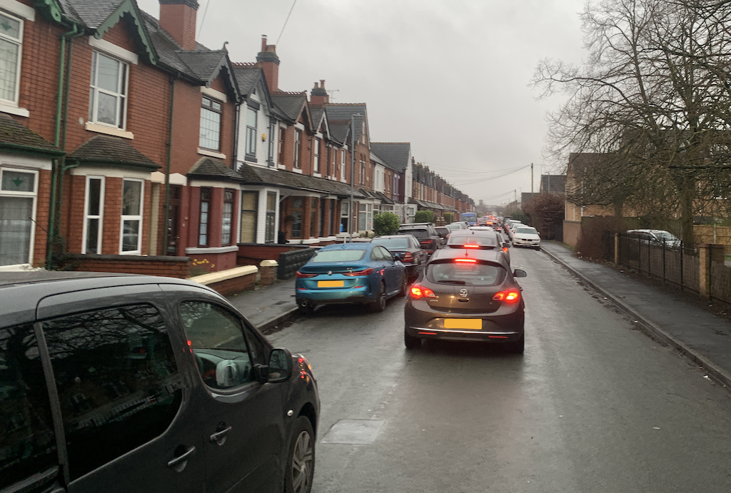
But in March what I particularly noticed was that it wasn’t simply the main roads through town that clogged up. As I walked my dog, I passed stationary vehicles backed up along my own (firmly residential) street. It seems that once the main A34 had backed up, satnavs started routing people around longer, less congested routes - ultimately gridlocking narrow residential roads.

Now admittedly I didn’t go car-to-car asking people if they were motorway traffic, or simply locals trying to avoid the snarl. And if they were off the motorway, whether their satnav had actively brought them down my road or if they’d devised their own route.
In either case they didn’t belong there, polluting the air outside a primary school. I’m not so hard-nosed as to insist that they should have stayed trapped on the M6 for 12 hours, but equally it’s an unfair imposition on local neighbourhoods for them to be sat idling on a residential street instead.
Now I’m a big fan of LTNs. Vehicles on a residential street should have business there - no through-traffic. This is only heightened with the volume of on-street parking (to which I am a contributor, full-disclosure - I’m part of the problem) and dangerously limited visibility of the pavements.
But I also recognise that the alt-right have made LTNs politically difficult, claiming various nebulous threats to democracy and that LTNs cause problems for bin collection and emergency access (despite there being a number of solutions to this).
What if you could have a Virtual LTN? Functionality provided by Google and other mapping providers where local councils could nominate streets or neighbourhoods as residents-only (“only route traffic here if it’s to a destination here - regardless of whether a through-route technically exists”). Open Street Map kind of supports this sort of behaviour with motor_vehicle:destination and similar provisions can be made using the Access and Conditional Restriction keys.
A Virtual LTN wouldn’t involve any planters or bollards across roads. Locals would be unimpeded. Reform and the ERG would have no cause for complaint (not that I care, but if you can do something beneficial without having to fight over it then so much the better). Despite a through-route existing, in the case of heavy traffic mapping services would refrain from shoving traffic down side streets and tight residential roads, even if it means keeping that traffic stationary on the main road.
I can think of a couple of obvious issues here.
-
Locals are usually the worst offenders. A typical complaint after the installation of speed cameras is that “they’re not supposed to catch people who live here”! Just the others who zoom through far too fast. A VLTN would stop distance travellers entering an area, but wouldn’t prevent day-to-day rat-running. Admittedly this isn’t really trying to stop normal rat-running, but the day-to-day benefit is probably limited (and many such routes have probably already been closed off over the years).
-
Such a system could be harmful in the event of some major incident where vehicles become fully trapped, despite the existence of an escape route. Conversely one might consider that keeping “back routes” clear for emergency services is beneficial, but it’s a possible unintended consequence to consider.
-
Such a system may then start dispersing that traffic way out into surrounding villages as it looks for a route around the town and VLTNs.
But implemented correctly, there are clear benefits too:
-
Residential roads are kept clear for active travel and emergency services.
-
Public safety. Had someone in my neighbourhood suffered a heart attack that day, paramedics would have had to abandon their ambulance and walk to the residence. Traffic kills.
-
Should autonomous cars become a thing, we really don’t want them cutting through back roads just because an algorithm says it’s quicker. This is classic tragedy of the commons/negative externality territory. The car - in optimising its own route - imposes noise, pollution on residential areas (which tend to have the worst signage and road markings, and the most obstacles such as parked cars) and endangers children and pedestrians far more than it would out on relatively clear A-roads where pedestrians tend to use marked crossings.
There are probably experienced mapping bods right now shaking their heads thinking “Oh sweet summer child”. The only thing I am confident of is that I’ve probably just glossed over many technical issues that I am blissfully ignorant of!
But it also seems like a not-insurmountable proposal. The mechanism to achieve this on a per-road basis already exists. It seems like more a policy issue of local authorities doing it (having considered strategic routes, utility and emergency access), and a matter of making sure that mapping providers honour such labels.